Visuals
The expansion area
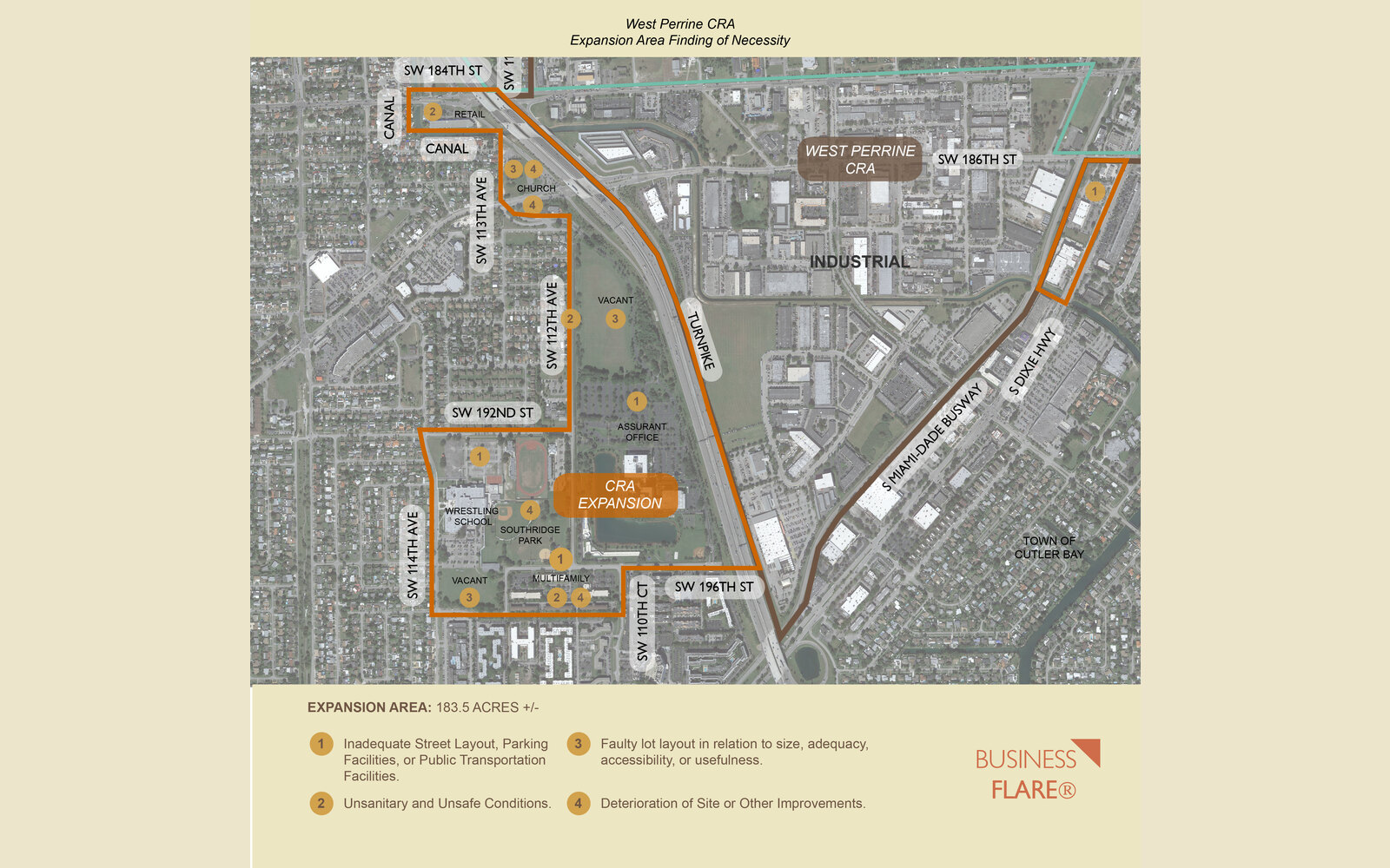
A statutory Finding of Necessity supporting a ~183.5-acre boundary expansion of Miami-Dade County's West Perrine CRA — documenting slum and blight conditions under Chapter 163 to unlock redevelopment.
West Perrine is an unincorporated community in southern Miami-Dade County, near Palmetto Bay and Cutler Bay, whose Community Redevelopment Agency was established by resolution on March 1, 2005. Under Resolution No. R-553-23 sponsored by Commissioner Kionne L. McGhee, the County engaged BusinessFlare® to prepare a Finding of Necessity for a proposed boundary expansion into an adjacent area of unincorporated land within the South Miami Heights census-designated place.
Conducted pursuant to Section 163.355, Florida Statutes, the study set out to determine whether the expansion area met the statutory definitions of slum and blight in Section 163.340(7) and (8). BusinessFlare® combined government-maintained data, property records, socioeconomic statistics, crime and fire-rescue data, and multiple boots-on-the-ground site reconnaissance visits to build a defensible record for County Commission approval.
The proposed expansion area meets the statutory tests for both slum and blight. Chapter 163 requires only one qualifying slum factor and two qualifying blight factors; BusinessFlare® documented two slum criteria (inadequate sanitation and conditions that endanger life or property by fire) and at least four blight criteria (defective/inadequate infrastructure, faulty lot layout, unsanitary or unsafe conditions, and deterioration of site improvements). On that basis, the report recommends the Board of County Commissioners approve the Finding of Necessity by resolution.
From the study-area boundary and statutory framework through the field evidence, socioeconomic profile, and public-safety data.
The proposed expansion adds approximately 183.5 acres of unincorporated land generally bounded by the Florida Turnpike to the east, SW 184th Street to the north, SW 114th Avenue to the west, and SW 197th Street to the south — within the South Miami Heights CDP. Land use is dominated by the Office Park District, with single- and multi-family residential and limited business zoning.
The evaluation followed Section 163.355, F.S., testing conditions against the slum and blight criteria in Section 163.340(7) and (8). The team layered government-maintained data, property records, Census/ACS socioeconomic statistics, and Miami-Dade Police and Fire Rescue data with multiple on-site reconnaissance visits — photographing 20 documented exhibits — so statutory language was matched to observed, recurring conditions.
Chapter 163 requires one qualifying slum factor and two qualifying blight factors. The report documents two slum factors — inadequate sanitation (illegal dumping, exposed trash, no dumpster enclosures) and conditions endangering life or property by fire (outdated overhead power lines and deteriorating structures) — and at least four blight factors, each tied to specific field and data evidence.
Census/ACS estimates for the expansion-area block group show acute distress compared to Miami-Dade County and the surrounding ZIP code: markedly lower incomes and home values, higher unemployment, and a poverty rate more than double the county figure — statutory indicators of economic distress that reinforce the physical evidence of blight.
Miami-Dade Police data show a persistent incidence of crime — larceny led Part I crimes in 2023, followed by motor-vehicle theft and aggravated assault. Miami-Dade Fire Rescue calls-for-service, while trending down year over year, remain proportionately high for such a small area, supporting the blight criteria for crime and fire/emergency service demand.
Because the area meets multiple slum and blight criteria — well beyond the statutory minimums — BusinessFlare® recommends the Miami-Dade Board of County Commissioners approve the Finding of Necessity by resolution. Following approval, the West Perrine CRA will amend its existing Community Redevelopment Plan to incorporate the expansion area, unlocking the framework for reinvestment.